Chilika Lake is a brackish water lagoon, spread over the Puri, Khurda and Ganjam districts of Odisha state on the east coast of India, at the mouth of the Daya River, flowing into the Bay of Bengal, covering an area of over 1,100 km.It is the largest coastal lagoon in India and the second largest brackish water lagoon in the world after The New Caledonian barrier reef.It has been listed as a tentative UNESCO World Heritage site.
It is the largest wintering ground for migratory birds on the Indian sub-continent. The lake is home to a number of threatened species of plants and animals.The lake is an ecosystem with large fishery resources. It sustains more than 150,000 fisher–folk living in 132 villages on the shore and islands.
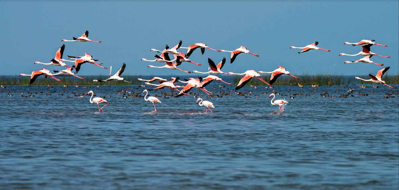
The lagoon hosts over 160 species of birds in the peak migratory season. Birds from as far as the Caspian Sea, Lake Baikal, Aral Sea and other remote parts of Russia, Kirghiz steppes of Kazakhstan, Central and southeast Asia, Ladakh and Himalayas come here. These birds travel great distances; migratory birds probably follow much longer routes than the straight lines, possibly up to 12,000 km, to reach Chilika Lake.
In 1981, Chilika Lake was designated the first Indian wetland of international importance under the Ramsar Convention.According to a survey, 45 percent of the birds are terrestrial in nature, 32 percent are waterfowl, and 23 percent are waders. The lagoon is also home to 14 types of raptors. Around 152 rare and endangered Irrawaddy dolphins have also been reported. Plus, the lagoon supports about 37 species of reptiles and amphibians.
The highly productive Chilika Lagoon eco-system with its rich fishery resources sustains the livelihood for many fishermen who live in and near the lagoon. The water spread area of the lagoon ranges between 1165 and 906 km2 during the monsoon and summer respectively. A 32 km long, narrow, outer channel connects the lagoon to the Bay of Bengal, near the village Motto. More recently a new mouth has been opened by CDA which has brought a new lease of life to the lagoon.Microalgae, marine seaweeds, sea grasses, fish and crab also flourish in the brackish water of the Chilika Lagoon. Especially the recovery of seagrass beds in recent years is a welcoming trend which may eventually result in re-colonization of endangered dugongs.
Geological evidence indicates that Chilika Lake was part of the Bay of Bengal during the later stages of the Pleistocene period (1.8 million to 10,000 years BP).Excavations were conducted by the Archaeological Survey of India at Golabai Sasan (20°1′7″N 85°32′54″E) just north of Chilika lake in Khurdha district.Golabai provides evidence of a sequence of Chilika area culture in three phases: Neolithic (c. 1600 BCE), Chalcolithic (c. 1400 BCE to c. 900 BCE) and Iron Age (c. 900 BCE to c. 800 BCE). Radiocarbon dating traced the earliest level of Golbai to 2300 BCE. The site is located on the left bank of the Malaguni River, a tributary of the Daya River, which flows into Chilika Lake. This location, which gave access to the sea via Chilika Lake, gives strong evidence of the maritime activities of this region. The recovery of many woodworking adzes and other artifacts shows that Golabai was a boat-building centre. Significantly, Golabai is the only excavated site in Odisha where boat building has been revealed. This also indicates that Chilika lake was very close to Golabai and it facilitated the maritime trade of people in the area during the ancient period.
Some ancient texts say the southern sector of Chilika was a major harbour for maritime commerce, when Kharavela (c. 209 BCE–after 170 BCE), the King of Kalinga, was known as the "Lord of the Sea".Ptolemy (150 CE), the Greek geographer, referred to Palur as the port Paloura, located close to the point of departure situated outside of the southern tip of the lake at Kantiagarh, from where ships bound for different parts of Southeast Asia sailed. After 639, the Chinese pilgrims Fa-Hien and Hiuen-Tsang mention a famous port "Che-li-ta-loChing" near the shore of the ocean which was a thoroughfare and resting place for seagoing traders and strangers from distant lands. This port was located at 'Chhatragarh' on the banks of Chilika Lake.
A fourth-century legend, often told to explain the birth of Chilika, states that the pirate king, Raktabahhu, planned to attack Puri with a huge fleet of ships. To avoid detection, he stealthily anchored out of sight, off the mouth to the sea. The deception was revealed by ships' refuse floating to the shore, thus warning the town's people, who escaped with all their possessions. Raktabahu felt betrayed when he found an abandoned town and directed his fury towards the sea that had betrayed him. The sea parted to let the army march in, then surged back, drowned the army and formed the present lake.
Archeological excavations discovered seventh-century ship anchors and stone memoirs dedicated to battle heroes at a village named Kanas, about 25 km (16 mi) north of Chilika on the banks of Nuna river, which flows into the lake. This gives evidence of a historic naval engagement off the coast.
A 10th-century text, the Brahmanda Purana, mentions Chilika Lake as an important centre of trade and commerce, and a shelter for ships sailing to Java, Malaya, Singhala, China and other countries. This suggests that the lake was then deep enough for berthing seagoing ships and had a channel to the sea big enough for loaded trading ships embarking to Southeast Asia.The villagers around Chilika Lake still observe an annual festival called "Bali Yatra" (Journey to Bali).
In 1803, the British entered the shores of the lake, reached Puri and occupied Odisha with the help of Fateh Muhammed. Fateh Muhammed, in turn, was rewarded by the British with freehold of the areas of Malud and Parikud, of the present day Garh Krishnaprasad revenue block.
Over the years, poets including Kabibar Radhanath Ray and Pandit Godavarish Mishra, freedom fighters and Saints have extolled historicity of the lake as pertinent to its cultural, spiritual, religious and scenic aspects.
The lake is of estuarine character in an ephemeral environment. Geological studies indicate that the coastline extended along the western shores of the lake in the Pleistocene era with its northeastern region lying under the sea. That the coastline has moved eastward over the ages is supported by the fact that the nearby Konarak Sun Temple, built originally on the seashore a few hundred years ago, is now about 3 km (2 mi), away from the coast.
The catchment area of Chilika lake has a rock, sand and mud substratum. It contains a wide range of sedimentary particles such as clay, silt, sand, gravel and shell banks but the major part of the catchment area is silt. Around 1.6 million metric tons per year of sediment is deposited in Chilika lake by rivers Daya and several streams.
It is conjectured that a rise in worldwide sea levels over the last 6,000–8,000 years occurred with a pause in the rise of sea level about 7,000 years ago, which could have resulted in the formation of a sandy beach near the coast at the Southern sector. With the rise in the sea level, the sand beach grew gradually, progressed seaward to the northeast and formed the spit of Chilika. A fossil unearthed from the southwestern edge of the spit indicates that the lake was formed about 3,500–4,000 years ago. The abrupt change in the direction of the coast north of the lake, strong winds shifting sand to the shore, longshore drift (littoral drift), the presence or absence of strong river and tidal currents in different areas are the reasons attributed for the growth of the spit.
White bands of coral in the southern sector, at a height of 8 m (26 ft), above the present water level, shows that the area was once marine and that the water was much deeper than present.The chronological development of the outer barrier spit of the lake has been dated by Optically stimulated luminescence studies of minerals. This was done on sixteen samples of the lake bed. The studies indicated doses of between 153 ± 3 mGy and 2.23 ± 0.07 Gy, corresponding to ages from 40 years at the top of the spit to 300 years at the bottom. The youngest ages are consistent with the age of the overlying vegetation. A clearly defined period of > 4.0 km (2.5 mi) of barrier construction 40 years ago is identified. Prior to that the deposition rate was relatively constant for 300 years.'
Chilika Lake is a shallow bar-built estuary with large areas of mudflats. The western and southern margins of the lake are fringed by the Eastern Ghats hill range.
Several inland rivers, which bring silt into the lake, control the northern end of the lake. A 60 km (37 mi) long barrier beach called Rejhansa,formed by northerly currents in the Bay of Bengal, resulted in the formation of this shallow lake and forms its eastern side. As an ephemeral lake, its water surface area varies from 1,165 km2 (449.8 sq mi) in the summer monsoon season to 906 km2 (349.8 sq mi) in the winter dry season.
The lake has numerous islands. The larger islands, separated by shallow channels, lie between the barrier and the main body of the lake. A total 42 km2 (16 sq mi) of channels connect the lake with Bay of Bengal.The six major islands are Parikud, Phulbari, Berahpura, Nuapara, Nalbana, and Tampara. These islands, together with the Peninsula of Malud, constitute the Krishnaprasad Revenue Block of Puri District.
The north shore of the lake is part of Khordha District and the western shore is part of Ganjam District. Due to siltation, the width of the barrier has fluctuated and the mouth to the sea has periodically been closed. The location of the mouth has also frequently shifted, generally towards the northeast. The mouth, which was 1.5 km (0.9 mi) wide in 1780, was only .75 km (0.5 mi) forty years later. The local fishermen, to maintain their livelihood, had to cut open the mouth regularly to gain access to the sea for fishing.
Water depth of the lake varies from 0.9 to 2.6 ft (0.3 to 0.8 m) in the dry season to 1.8 to 4.2 m (5.9 to 13.8 ft) in the rainy season. The width of the old channel to the sea, now reported to be about 100 m (330 ft), is known as Magarmukha (Mouth of the Crocodile). The lake is divided into four separate zones namely, the southern, central, northern sectors and the outer channel area. A 32 km (19.9 mi) long outer channel connects the lake with the Bay of Bengal at Arakhuda village. The lake is vaguely pear shaped and has a maximum length of 64.3 km (40.0 mi) with a mean width of 20.1 km (12.5 mi).
Three hydrological subsystems control the Hydrology of the lake. The land-based system comprises distributaries of the Mahanadi River on the northern side, 52 river channels from the western side and the Bay of Bengal on the eastern side. Two of the three southern branches of the Mahanadi River that trifurcates at Cuttack, feed the lake. 61% (850 m3/s (30,000 cu ft/s)) of the total freshwater inflow into the lake is contributed by these two branches.
The second drainage system which is non–perennial accounts for 39% (536 cubic metres per second (18,900 cu ft/s)). The important rivers of this drainage system are the Kansari, the Kusumi, the Janjira, and the Tarimi rivers. The annual total surface freshwater input to the lake is estimated to 1.76 cubic kilometres (1,430,000 acre⋅ft) including direct precipitation over the lake contributing 0.87 cubic kilometres (710,000 acre⋅ft) All the inland river systems disgorge an annual flow of about 0.375 million cubic metres (304 acre⋅ft) of freshwater which is estimated to carry 13 million metric tons of silt into the lake. On the northeast, a channel connects the lake to the Bay of Bengal.
A tropical monsoon climate prevails over the drainage basin area of the lake. The lake experiences South–west and North-east monsoons during June to September and November to December respectively with an average annual rainfall of 1,238.8 mm (48.77 in), with 72 rainy days. The maximum temperature of 39.9 °C (103.8 °F) and minimum temperature of 14 °C (57.2 °F) have been recorded. The wind speed varies from 5.3 to 16 metres (17 to 52 ft)/hourwith southerly and southwesterly direction due to the influence of the Southwest monsoon and from the north and northeasterly direction during the rest of the months.
Over a million migratory waterfowl and shorebirds winter here.Over 400 vertebrate species have been recorded.As an estuarine lagoon, it supports a unique assemblage of marine, brackish and freshwater species.Several rare and endangered species are found in the region.The lake supports fisheries that are the lifeline of the community.The lake is of great value in preserving genetic diversity.There is an Increase in weeds and aquaculture activities.
The ecological richness of the lake is of great value in preserving the genetic diversity because of the multiplicity of its habitat, flora and fauna. (Some are pictured in the photo gallery).The Zoological Survey of India (ZSI) surveyed the lake between 1985 and 1988 and identified 800 species of fauna, including many rare, endangered, threatened and vulnerable species, but excluding terrestrial insects.
The rare and threatened animal species identified are green sea turtle (EN), dugong (VU), Irrawaddy dolphin (EN), blackbuck (NT), Spoon billed sandpiper (CR), Chilika limbless skink (CR) and fishing cat (VU). 24 mammalian species were reported. 37 species of reptiles and amphibians are also reported.
For centuries fisher folk evolved exclusive rights of fishing through a complex system of partitioning the fisheries of the lake, harvested the lake in a relatively sustainable fashion and developed a large range of fishing techniques, nets and gear.
During the British rule, in 1897–98, fishermen community enjoyed exclusive fisheries rights in the lake. The fisheries of the lake were part of the Zamindari estates of Khallikote, Parikud, Suna Bibi, Mirza Taher Baig and the Chaudhary families of Bhungarpur and the Khas Mahal areas of Khurda, lying within the kingdoms of the Rajas of Parikud and Khallikote. The zamindars (Landlords) leased out the fisheries exclusively to the local fisherfolk.
With the abolition of zamindari (land lordship) system in 1953, traditional fishing areas continued to be leased out to cooperatives of local fishermen. Fishing, particularly, prawn fishing, became increasingly remunerative with outside interest playing an important role. But in 1991, when the government of Odisha proposed a leasing policy that would have resulted in the auction of leases to the highest bidder, the Fishermen's cooperatives challenged the order in court. The High Court of Odisha ordered the Government to enact changes that would protect the interests of traditional fishermen and since then no new leases have been reported. This has resulted in a chaotic regime in which powerful vested interests from outside dominate, and the local people have been subordinated.
Butter catfish and Wallago attu are the most common type of fish found in the lake. 11 species of fish, 5 species of prawn and 2 crab species are commercially important. The commercially important prawn are giant tiger prawn (Metapenaeus monoceros), Indian prawn (Penaeus indicus), Metapenaeus monoceros (Speckled shrimp), Metapenaeus affinis (Pink prawn) and Metapenaeus dobson (Kadal shrimp). Mangrove crab is the most important commercial crab.Fish landings in the lake, which fluctuated in the past, have recorded a remarkable recovery after the opening of the new mouth and dredging of silt –choked old mouth Magarmukh in 2000–2001, resulted in a better intermixing of the tidal influx from the sea and freshwater inflow from rivers. Against an all time lowest landing of fish and prawn of 1,269 t (1,399 short tons) in 1995–96, the all-time high is reported to be 11,878 t (13,093 short tons) during 2001–2002 resulting in an estimated per capita income for the fisher folk of Rs 19,575 (about US$392) during the year. Recently, the Government of Odisha have issued a notification banning the lease of Chilika Lake for Culture Fishery.
The Irrawaddy dolphin (Orcaella brevirostris) is the flagship species of Chilika lake. Chilika is home to the only known population of Irrawaddy dolphins in India and one of only two lagoons in the world that are home to this species.
It is classified as Endangered according to International Union for Conservation of Nature(IUCN).
A small population of Bottlenose dolphins, also migrate into the lagoon from the sea.Chilika fishermen say that when Irrawaddy dolphins and bottlenose dolphins meet in the outer channel, the former get frightened and are forced to return toward the lake.
Some Irrawaddy dolphins used to be sighted only along the inlet channel and in a limited portion of the central sector of the lake. After the opening of the new mouth at Satapada in 2000, they are now well distributed in the central and the southern sector of the lake.The number of dolphins sighted has varied from 50 to 170. A 2006 census counted 131 dolphins and the 2007 census revealed 138 dolphins. Out of the 138 dolphins, 115 were adults, 17 adolescents and six calves. 60 adults were spotted in the outer channel followed by 32 in the central sector and 23 in the southern sector.
Dolphin tourism provides an important alternative source of income for many local residents. There are four tourist associations in Satapada employing three hundred and sixty 9-HP long-tail motor boats taking tourists to a 25 km2 (9.7 sq mi) area of the lake for dolphin watching. About 500 fishing families are involved in this business.The Odisha Tourism Department and the Dolphin Motorboat Association, an NGO at Satpada, report about 40,000 tourists visit Chilika every year for dolphin watching. October–January, and May–June are the peak season for tourists at Chilika, with a maximum 600-700 per day during December–January. The Dolphin Motorboat Association has 75 8-passenger motorboats for dolphin watching. Tourists pay Rs. 250 for 60–90 minutes per trip(approx ₹4k for 10 people with 3.5 hours in a private boat in 2018). According to the Association, most tourists see dolphins. Only 5% return disappointed. Besides the Association, the Odisha Tourism Department organises "dolphin-watch" for tourists. Even during monsoon, about 100 tourists/day visit the lake.
Boat based dolphin watching tours impact dolphin behavior and cause several accidental dolphin deaths each year.CDA conducts an annual census of dolphin deaths. They report 15 deaths in 2003–04, 11 in 2004–05, 8 in 2005-06 and 5 in 2006–07. 40% of the 2006-07 deaths were by mechanised boats.
Since 2004, the Whale and Dolphin Conservation Society has been conducting a science-based community education project to conserve the Irrawaddy dolphins and Chilika Lake. They have determined the primary cause of mortality for this population of dolphins is floating gill nets and hook line fisheries and the secondary cause is boat strikes from increasing unmanaged tourism activities.
The Irrawaddy dolphins have a seemingly mutualistic relationship of co-operative fishing with the traditional fishermen. Fishermen recall when they would call out to the dolphins, to drive fish into their nets. Castnet fishing with the help of Irrawaddy dolphins in upper reaches of the Ayeyawady River has been well documented.
The 15 km2 Nalaban Island is within the Lagoon and is the core area of the Ramsar designated wetlands. It was declared a bird sanctuary under the Wildlife Protection Act in 1973. It is the heart of the park where one can seen thousands of birds descending during the migratory season. The island disappears during monsoon season due to inundation, and post-monsoon, the island emerges again.
The vast lake harbours 225 species of fish, a wide variety of phytoplankton, algae and aquatic plants, and also supports over 350 species of non-aquatic plants. The other areas where high concentrations of birds are recorded are Gerasara, Parikud Island, and the western shores of the Northern sector.
The open air and scenic natural flora and fauna of the lake are an attraction for eco-tourism. This is expected to provide a degree of alternate employment to the local community and generate environmental awareness, among local residents as well as visitors, about the conservation and wise use of the lake's natural resources. The locations within the lake identified for such activity are:Rambha Bay at the southern end of the lake with the group of islands including:The Becon Island, with an architectural conical pillar (to put a light on the top) built by Mr. Snodgrass, the then collector of Ganjam of the East India Company, on a mass of rock in the Rambha Bay near Ghantasila hill. It has scenic water spread surrounded by the Eastern Ghat.
The Breakfast Island, pear-shaped, known as "Sankuda island", with remnants of a dilapidated bungalow constructed by the King of Kalikote, has rare plants and is full of greenery with appealing flora.
Honeymoon Island, 5 km (3 mi) from Rambha Jetty, known as Barkuda Island, with clear waters has abundant red and green macro algae in the bed is also known for the limbless lizard, an endemic species found here.
Somolo and Dumkudi islands, located in the Central and Southern sectors of the lake, in the backdrop of scenic Khalikote hill range, are inundated remnants of the Eastern Ghats with rich flora and fauna and also known for sighting of Irrawaddy dolphins.
Birds' island, located in the southern sector of the lake has huge exposed hanging rocks, are painted white due to folic acid of the droppings of the birds and is known for rich algal communities and few mangrove species and also migratory birds in winter.Parikud is a group of composite islands in the Garh Krishnaprasad Block for nature lovers and provides an avian spectacle during winter season.Kalijai Temple located on an island is considered to be the abode of the Goddess Kalijai. This temple is located at a hill which is surrounded by blue water bears. Local people of Chilika refer to goddess as the reigning deity of the lagoon.
Satapada village, at the new mouth of the lake, provides a view of the Lake and also views of the dolphins. Hundreds of boats here provide tours of the lake for tourists.Barunkuda, a small island situated near Magarmukh, the mouth of the lake, has a temple of Lord Varuna.Nabagraha is an ancient deity located along the outer channel.Chourbar Shiva Temple is located near Alupatna village, along the outer channel.Manikapatna, located on the outer channel has historical evidence of a port which was used for trade with Far East and also has the Bhabakundeswar temple of Lord Shiva, an old Mosque whose entrance door is made of the jaws of the whale.Sand-Bar and Mouth of the Lake is a striking and un-explored stretch of 30 km (20 mi) of empty beach across the sand bar which separates the Lake from the Sea.Mangalajodi a famous bird sanctuary for sighting migratory birds.
"Gopabandhu Das, a famous Odiya poet, became impatient to see the beauty of the march of colorful sights and sounds of Chilika lagoon while going by train. He asked the speeding train to stop for a moment so that he could enjoy the beauty. It is because of the beauty that arrests him much".